CDA Lake Drive Project and East Sherman Pilot Project Conclusion
East Sherman/CDA Lake Drive – Changes Explained
This press release is being provided by the City of Coeur d’Alene to provide helpful information and facts about current and upcoming public projects within the East Sherman area.
Coeur d’Alene Lake Drive Roadway Configuration Changes:
You may have noticed some changes to the pavement markings on Coeur d’Alene Lake Drive and may be a bit confused about the reason for the new configuration. A master plan for Coeur d’Alene Lake Drive was developed with public input. The new striping and pavement markings reflect the master plan and delineate the Centennial Trail and bike lanes with a goal of improved safety for all users. Below you will find a brief summary of the changes. If you are interested in the history of the project and answers to some questions we have seen in the Letters to the Editor, visit https://www.cdaid.org/east-sherman-master-plan.
As a part of negotiations for the jurisdictional transfer of Coeur d’Alene Lake Drive from the Idaho Transportation Department (ITD) to the City of Coeur d’Alene, a master plan was developed for the corridor. Between 2016 and 2018, public meetings were conducted to collect comments on the future of the corridor and guide the jurisdictional transfer. In January of 2018, the City of Coeur d’Alene Council approved the master plan and the jurisdictional transfer of Coeur d’Alene Lake Drive from Sherman Ave to Silver Beach Road. Similarly, ITD transferred the remaining portion to Higgins Point to Eastside Highway District. Changes to the corridor were delayed until the surface could be improved to allow for the new striping configuration per the approved Coeur d’Alene Lake Drive Master Plan.
This year, Eastside Highway District and the City partnered to apply a chipseal surface to the corridor to preserve its life. In an effort to meet the goals of the master plan and to make efficient use of taxpayer funds, Coeur d’Alene Lake Drive was reconfigured through restriping to the current three-lane section.
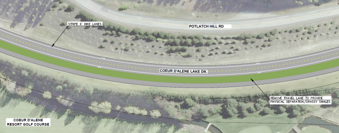
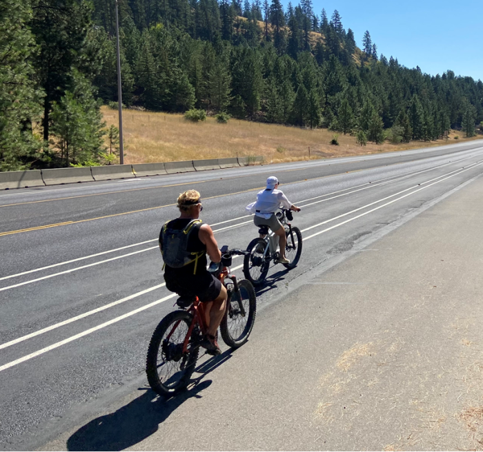
Although no pavement is planned to be removed between the Centennial Trail and the travel lanes at this time, an approved future development between the Coeur d’Alene Golf Course and Bakery by the Lake will provide the desired separation at the time of construction. In the short-term, additional pavement markings will be installed on the Centennial Trail to better define it as strictly for use by pedestrians and bicyclists. The new bike lanes adjacent to the travel lanes are intended for faster-moving athletic bicyclists to avoid conflicts on the trail where slower-moving sight-seers, dog-walkers, and others enjoy the trail. Double white lines were installed next to the bike lanes to create a buffer space, providing additional separation between the motor vehicle travel lanes and the bike lanes. The new bike lanes on each side of the roadway are designed for one-way traffic, as indicated by the arrows. Additional double-white-lines were installed to separate the bike lane from the Centennial Trail. In the future, pavement may be removed and landscaping added to accomplish this separation. Please note, parking and driving within the Centennial Trail is not permitted and the master plan does not call for future on-street parking along Coeur d’Alene Lake Drive.
A two-way left turn lane was added to provide safe left-turn areas and separation between directions of travel. Prior to the restriping, no left turn lane was available at the Coeur d’Alene Golf Course or at the Rutledge Trailhead. The new configuration for Coeur d’Alene Lake Drive meets the intent of the Coeur d’Alene Lake Drive Master Plan, increases separation between the Centennial Trail and motor vehicle traffic, reduces potential trail conflicts, improves safety for turning vehicles, and reduces future maintenance costs. See images below for the master plan concept and photos of the new pavement markings.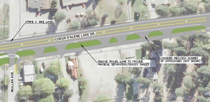
East Sherman Pilot Project Concluding:
The “Activate East Sherman” Pilot Project on the 1600 block of East Sherman will be concluding after the Labor Day weekend. On September 7th, volunteers will be removing the parklet seating structure in front of Moon Time and moving planters out of the street. The City’s Streets and Engineering crew will be moving through the area starting on September 12th, weather permitting, to remove the white reflective bollards and revert the parking spaces and roadway centerline back to the original configuration. The City-owned pocket park on this block will remain, along with the benches and planters on the sidewalk that were donated for the Pilot Project.
You may wonder why the pilot project is concluding, and what will happen next. Following the initial launch, the City heard mixed responses from business owners, residents and City leaders, as well as City staff on how well some of those Pilot Project design and amenities have been working. One of the main concerns was with safety on the block as a result of the traffic diversion and “bulb outs” at the intersections because the temporary improvements were only on one block. There were also issues with snow removal. City Engineer, Chris Bosley, evaluated East Sherman from 13th Street to 17th Street to see if diagonal parking could be accommodated for more than one block and if it would gain additional parking spaces. It was determined that the parking count would not increase with the diagonal parking configuration due to the number of driveway approaches along the corridor. There wasn’t a great way to continue the diagonal parking for more than one block and keep it on one side of the street. Additionally, there would be more challenges with alternating the diagonal parking from one side of the street to the other, as it requires more diversions and curves in the road. It was determined that the Pilot Project has provided useful feedback, but that it is time for it to conclude and other options to be evaluated – as it was only intended to be temporary.
The City and our partners at CDA 2030 are interested in supporting the businesses and property owners with positive transformation of the East Sherman area and further evaluating roadway designs and enhancements but that will require removal of the Pilot Project street diversion and parklet seating structure. We would like to get input from business and property owners within the East Sherman corridor on some of the other street design alternatives that were included in the draft East Sherman Revitalization Plan. The plan is to reconvene the East Sherman Leadership Committee and bring on new members to vet some of these ideas and discuss other desired changes to the corridor. Stay tuned for more information about East Sherman in the coming months. To review the DRAFT East Sherman Revitalization Plan from December 2019 (not yet adopted by the City Council) visit www.eastsherman.org.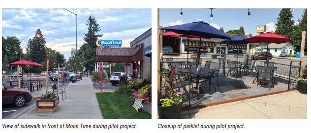
710 E. Mullan Ave
Coeur d'Alene, ID 83814
Phone: 208.769.2300
8:00am - 5:00pm
Monday - Friday
©2026 All rights reserved
Privacy Policy


